PV Area Info

History of the Area

A VALLEY RICH IN HISTORY…

When European settlers first came to what would be called Pennsylvania, they found about 15,000 Native Americans, most from the Delaware or Lenni-Lenape tribe, living primarily in the southeast section.

What is now the Commonwealth of Pennsylvania (“Penn’s Woods”) was created on March 4, 1681 by King Charles II of England. He granted William Penn, a prominent Quaker, most of what we know as Pennsylvania to repay a debt owed Penn’s father, Admiral William Penn.

Pennsylvania later became known as the Quaker State and the Keystone State, the latter name suggesting its position in the arch of the 13 original colonies.

The Perkiomen Valley was important from Pennsylvania’s earliest days because its rich farmlands provided food for residents of Philadelphia. During the Revolutionary War, Washington’s troops wintered in nearby Valley Forge.

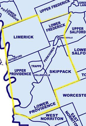
Montgomery County was formed in 1784 from land taken from Philadelphia. Limerick Township is one of the first townships formed in Montgomery County. Limerick’s original settlers came from Germany and Holland in the early 18th century. The township’s borders took their current form in 1879 with the separation of Royersford Borough. Today, Limerick Township is the fastest growing area within the Perkiomen Valley. There are many new residential developments because of the new 422 Expressway that runs through Limerick from King of Prussia to Pottstown. It is also home to PECO Energy Company’s Limerick Nuclear Generating Station, the Pottstown-Limerick Airport, and several golf courses.

“Skippack and Perkioming Township,” as it was known then, was formed in 1725. In 1886 it divided into Skippack Township and Perkiomen Township, separated by the Perkiomen Creek. Perkiomen Township includes Rahns and Graterford, although most properties have Collegeville mailing addresses. Skippack Township includes Creamery and Skippack Village, which contains many small antique and craft shops.

The first copper mine in Pennsylvania was operating near Schwenksville before 1720. For a time after the railroad reached Schwenksville in 1869, this area was a summer resort on the Perkiomen Creek. Schwenksville Borough was incorporated in 1903, with its original land coming from Perkiomen Township. Schwenksville reached its current form in 1972 with the addition of land from Lower Frederick Township.

Lower Providence Township and Upper Providence Township were created in 1805 by splitting Providence Township in two. Both townships were largely agricultural until recently. Lower Providence Township includes Audubon, Eagleville, Evansburg, Trooper and the Valley Forge Industrial Park and Corporate Center.

John James Audubon (1785-1851) had his first home in America at Mill Grove in Lower Providence Township. The French-American ornithologist was noted for his bird drawings and paintings, published in Birds of America.

The largest developments in Upper Providence Township are at the intersection of the 422 Expressway and Route 29: GlaxoSmithKline, and the headquarters of Wyeth Pharmaceuticals. Upper Providence includes Mont Clare and Oaks.

Collegeville (formerly called “Perkiomen Bridge” and “Freeland”) and Trappe were incorporated in 1896 from land that had been part of Upper Providence Township. Freeland Seminary was founded in 1848 by Abraham Hunsicker in what is now Collegeville. Ursinus College purchased it in 1869. Pennsylvania Female College was founded in 1851 and closed in 1880, at which time Ursinus began to admit women.

Until the Pennsylvania Turnpike and the more recently opened 422 Expressway, Collegeville and Trappe had a strategic position at the midpoint of the Philadelphia-Reading Pike. The Perkiomen Bridge Hotel, built in Collegeville in the 1700s, is one surviving example of the taverns and inns built to service this travel trade.

Henry Melchior Muhlenberg, whose restored home is on Main Street in Trappe, founded the Lutheran Church in America. His eldest son, John Peter Gabriel Muhlenberg, became a major general in the Continental Army, was a vice-president of Pennsylvania and a U.S. representative. Another son, Frederick Augustus Conrad Muhlenberg, served various Lutheran congregations until he was elected to the Continental Congress in 1779. A member of the U.S. House of Representatives, he was its first Speaker. A grandson, Henry Augustus Philip Muhlenberg, was the first U.S. minister to Austria.

Lower Frederick Township and Upper Frederick Township were formed in 1919 with the division of Frederick Township. Their original settlers were of Pennsylvania Dutch descent. Mostly still rural and agricultural, this area has experienced residential development. Lower Frederick Township includes Spring Mount and Zieglerville. Upper Frederick Township includes Frederick, Obelisk, Perkiomenville, and Montgomery County’s 536 acre Upper Perkiomen Valley Park.

…WITH EVEN MORE TO OFFER TODAY

Early on, middle-class Philadelphians would try to escape the summer heat by riding the train out of the city to retreat to their summer homes along the Perkiomen Creek in Collegeville, Schwenksville, Skippack and Trappe. When the transportation infrastructure–particularly highways–was developed, people began to live here year-round and commute to their jobs in the city.

So the Perkiomen Valley came to be known as a bedroom community, one that retained its rich heritage and pleasant rural lifestyle. In more recent decades, companies began moving to this area, too, to escape the growing problems of the inner city, to attract skilled labor, and to be more conveniently located for their employees and customers.

Most recently this trend has accelerated as technological developments in telecommunications and computers have enabled all businesses, not just those located in major cities, to look at and service markets with a more national and international perspective.

Today, the valley continues to grow and prosper while preserving its history, culture and unique, small-town sensibility.

Growth is a key word in this area. In the most recent census (2010), the Perkiomen Valley had a population of 102,416.  This represents tremendous growth in the region since 2000.

Perkiomen Valley Municipalities

Collegeville Borough

Member of the PV Chamber
www.collegeville-pa.gov
P.O. Box 480, Collegeville, PA 19426
610-489-9208
2010 Population: 5,089
Size: 1.64 square miles
Public School District: Perkiomen Valley School District
Much of Collegeville retains its nineteenth century village flavor in addition to its recent residential developments. Ursinus College’s beautiful campus adds a wonderful touch to this small community. Some Collegeville mailing addresses may actually be located in Lower Providence, Upper Providence, Skippack or Perkiomen Townships. SEPTA bus routes travel through Main Street Collegeville allowing access to Norristown, King of Prussia and Pottstown. The borough contains Main Street retail businesses and two community shopping centers.

Limerick Township

646 West Ridge Pike
Limerick, PA 19468
610-495-6432
2010 Population: 18,074
Size: 22.39 square miles
Public School District: Spring Ford Area School District
Today, Limerick is one of the hottest development areas in the county. The much acclaimed 422 Expressway runs through the heart of the township and is assisting in the area for development. The township hosts golf courses, a nuclear generating station, an airport, as well as quality residential areas, and open space. Shopping Centers, hotels and recreation can be found throughout the township.

Lower Frederick Township

Member of the PV Chamber
www.lowerfrederick.org
53 Spring Mount Road, P.O. Box 253
Zieglerville, PA 19492
610-287-8857
2010 Population: 4,840
Size: 8.19 square miles
Public School District: Perkiomen Valley School District
Settled primarily by people of Pennsylvania Dutch descent, the township has been historically agricultural and retains its rural and Pennsylvania Dutch characteristics.
Today, some residential and commercial development is adding to the township’s population.

Lower Providence Township

Member of the PV Chamber
www.lowerprovidence.org
100 Parklane Drive
Eagleville, PA 19403
610-539-8020
2010 population: 25,436
Size: 14.77 square miles
Public School District: Methacton School District
Eagleville and Trooper attract business and residential development. One of the county’s largest industrial parks is located here: the Valley Forge Industrial Park and Corporate Center. The American Revolution Center is establishing the world’s first center to commemorate the entire story of the American Revolution on 78-acres in Valley Forge adjacent to Valley Forge National Historical Park.  Today, the township has a unique balance of residential, commercial, industrial, and open space land uses.

Perkiomen Township

Member of the PV Chamber
www.perkiomentownship.org
1 Trappe Road
Collegeville, PA 19426
610-489-4034
2010 population:  9,139
Size: 4.72 square miles
Public School District: Perkiomen Valley School District
Fastest growing township in 1990’s. Communities within the township include Rahns and Graterford. A SEPTA bus route connects the Graterford and Rahns sections of the township with Collegeville. A large food market and pharmacy are located in the heart of the township.

Schwenksville Borough

Member of the PV Chamber
http://schwenksville-pa.org/
140 Main Street
Schwenksville, PA 19473
610-287-7442
2010 Population: 1,385
Size: .55 square miles
Public School District: Perkiomen Valley School District
Schwenksville has little land remaining for development and remains a small quaint residential community. Small businesses and shops are located on the borough’s Main Street.

Skippack Township

Member of the PV Chamber
www.skippacktownship.org
P.O. Box 164, 1246 Bridge Road
Skippack, PA 19474
Office Hours 8:00 a.m. to 4:30 p.m.
610-584-5453 Fax 610-584-8966
2010 Population: 13, 715 (an increase of 110% from 2000 census)
Size: 14 square miles
Organized in 1886, Skippack is a rural, quaint community full with antique, craft, art and specialty shops. Many historical sites and history notes in Skippack including the fact that George Washington stayed here on his way to Valley Forge, also hosts site of Evansburg State Park.

Trappe Borough

Member of the PV Chamber
www.trappeboro.com
525 West Main Street
Trappe, PA 19426
610-489-7181
2010 Population: 3,059
Size: 2.26 square miles
Public School District: Perkiomen Valley School District
There are many small businesses along the Main Street of the borough along with old historic landmarks which have been nicely preserved. A SEPTA bus route runs along the Main Street of the borough. This route allows access to Pottstown and Norristown and various points in between. A community shopping center is serving area residents located right on the Main Street.

Upper Providence Township

1286 Black Rock Road, P.O. Box 406
Oaks, PA 19456
610-933-9179
2010 population: 21,219
Size: 18.20 square miles
Public School District: Spring Ford School District
The Route 422 and Route 29 intersection has three significant facilities and the Providence Corporate Center will open in late 2009. Oaks and Mont Clare are two recognizable villages in the township with shopping, movies and restaurants and the Greater Phila. Expo Center located at the Oaks exit of Route 422 . The Mont Clare and Oaks portions of the township are serviced by a SEPTA bus route. This allows access to Phoenixville and Norristown. Small businesses and some shops are located throughout the township.

Montgomery County Trails

Experience the Trails*

“Montgomery County offers its residents and visitors a premier trail system. The Montgomery County Division of Parks, Trails, and Historic Sites is responsible for constructing and maintaining all county trails. We currently have almost 60 miles of regional county trails connecting greenways, waterways, and heritage corridors within Montgomery County and are planning to construct additional trail miles.

We diligently enhance, promote, and protect these valuable natural assets. We strive to provide trail visitors with an exceptional experience while they traverse through Montgomery County on foot, bicycle, or even horseback. View a map of the trails and plan your next adventure.”


View Trail Information Here.


*Information taken from Montgomery County Website.